united nations imgw tool

Real-time data-driven analysis and programming in crisis contexts.

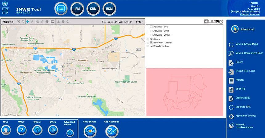
IMWG Tool is an application developed for the United Nations (UNDP) for strategic planning and decision-making. It helps UNDP, government partners, and humanitarian actors with crisis mapping, conflict analysis and strategic planning and coordination.

We developed this platform using different GIS providers such as Google Maps, Open Street Maps, Ushahidi. The most important feature is its capability to collaborate peer-to-peer and to sync data so that it can be used in scenarios where internet reliability is an issue. This application is being used by United Nation teams in Sudan and Jordan.

1
2
3
4
5
6
1

CHALLENGE

Create a tool for the Information Management (IM) challenges United Nations Coordinators are facing in countries in crisis situations. They required data and information management systems to support strategic analysis, and subsequent programming and coordination for development interventions.
2

SOLUTION

IMWG Tool is an application that uses a Geographical Information System that works online and offline with a distributed database.
3

OUTCOME

A GIS-based platform to manage risk mapping, security incident tracking, project management and basic service monitoring elements. This tool greatly enhances partners' capacities for coordinated targeting, design and monitoring of interventions.

How does the Risk and Problem Mapping work?

The Risk and Problem Mapping is carried out through a multi-actor consultation process that identifies, prioritizes, categorizes and geo-references the main risks and their associated problems, then brings the results into the tool. The results can then be visualized and searched in the same way as the 4Ws (Who, What, Where, When).

A critical feature of the IMWG Tool is that it works on a common Map background so that the user can select and filter any particular dataset.

united nations dashboard
united nations IMAS toolkit

IMWG Tool Components

The IMWG Tool has four main components with a common mapping system:

  • Who, What, Where, When (4Ws) tracking and mapping tool.
  • Municipal Risk and Problem Mapping.
  • Non-Humanitarian Financial Tracking.
  • Country Digital Atlas, the foundation for the whole toolkit, provides contextual data and analytical displays for the dynamic overlaying of data from the other three components.

IMWG Visualization

The IMAS Toolkit‘s most salient feature is the ability to allow users to filter, select and display data from the various Tool components and display them not only on the common basic map, but also to dynamically display any selection on the country Digital Atlas where it can be overlaid with all relevant info layers. The Toolkit supports joint analysis, planning, coordination and M&E.

Let’s work together

Turn your idea into a reality. San Francisco App Developers.